
|
تاریخ : شنبه 31 فروردین1403 - 12:18am |
|
همه زمان ها بر اساس UTC + 3:30 ساعت تنظیم شده اند. |
|
|
صفحه 28 از 53 |
[ 529 پست ] | برو به صفحه قبلی 1 ... 25 , 26 , 27 , 28 , 29 , 30 , 31 ... 53 بعدی |
| حالت پرینت | موضوع قبلی | موضوع بعدی |
سیستم های ماهواره ای
| نویسنده | پیغام |
|---|---|
|
کاربر حرفه ای   تاریخ عضویت: چهارشنبه 27 خرداد1393 - 12:27am پست: 320 |
سورناي عزيز اگه شما از ماهواره اطلاعات دارين لطفا ما رو هم راهنمايي بكنين و اسم ماهوارهاي كه اين اسكن ها رو ميگيره بزارين اگه موقعيتش رو بزارين كه عالي ميشه در ضمن اگه يك همچين ماهواره هايي بود الان صد در صد دولت ها بهش پارازيت مينداختند
من خودم كه باور ندارم كه بشه با ماهواره اين كارها رو كرد  البته به دوربينهاي uwb اعتقاد دارم ولي فكر نميكنم سنسوري بتونه ساخته بشه كه در فواصل دور شبيه اين دوربين ها عمل كنه البته اين آمريكاييهاي لعنتي تمامي نخبگان دنيا رو جمع ميكنند و ازشون بهره ميبرند البته به دوربينهاي uwb اعتقاد دارم ولي فكر نميكنم سنسوري بتونه ساخته بشه كه در فواصل دور شبيه اين دوربين ها عمل كنه البته اين آمريكاييهاي لعنتي تمامي نخبگان دنيا رو جمع ميكنند و ازشون بهره ميبرند  |
| چهارشنبه 11 شهریور1393 - 1:56am |
|
|
کاربر حرفه ای  تاریخ عضویت: جمعه 2 آبان1392 - 12:21am پست: 965 |
l24nb0 نوشته است: خالی بندی 100 درصد هیچ سیستمی وجود نداره کمی فکر کن اگر بود تا به حال تمام کارهای اتمی ایران لو رفته بود دقیقاً. احسنت.  و یا اینکه دلیلی نداشت خودشونو بکشن که پهباد بفرستن رو تأسیسات اتمی شاید چیزی گیرشون بیاد. و یا اینکه دلیلی نداشت خودشونو بکشن که پهباد بفرستن رو تأسیسات اتمی شاید چیزی گیرشون بیاد. |
| چهارشنبه 12 شهریور1393 - 11:13am |
|
|
تاریخ عضویت: یکشنبه 14 مهر1392 - 5:57pm پست: 15 |
تخیلی بیش نیست.لعنت خدا بر فریبکاران لعنت بر کسی که مردم ساده را فریب میدهد (لامصب چطور اون نون رو میخوری)
|
| جمعه 28 شهریور1393 - 12:26pm |
|
|
کاربر فعال  تاریخ عضویت: جمعه 1 شهریور1392 - 4:52pm پست: 67 |
سلام
اول از همه ، این مطلب را گوگل کنید: Remote sensing Remote sensing satellite دوم: بروید اینجا: http://en.wikipedia.org/wiki/Remote_sensing سوم : این تصویر را از همان لینک بالایی ببینید: http://upload.wikimedia.org/wikipedia/commons/2/20/Death-valley-sar.jpg چهارم: این پاراگراف را بخوانید: Applications of remote sensing data Conventional radar is mostly associated with aerial traffic control, early warning, and certain large scale meteorological data. Doppler radar is used by local law enforcements’ monitoring of speed limits and in enhanced meteorological collection such as wind speed and direction within weather systems in addition to precipitation location and intensity. Other types of active collection includes plasmas in the ionosphere. Interferometric synthetic aperture radar is used to produce precise digital elevation models of large scale terrain (See RADARSAT, TerraSAR-X, Magellan). Laser and radar altimeters on satellites have provided a wide range of data. By measuring the bulges of water caused by gravity, they map features on the seafloor to a resolution of a mile or so. By measuring the height and wavelength of ocean waves, the altimeters measure wind speeds and direction, and surface ocean currents and directions. Light detection and ranging (LIDAR) is well known in examples of weapon ranging, laser illuminated homing of projectiles. LIDAR is used to detect and measure the concentration of various chemicals in the atmosphere, while airborne LIDAR can be used to measure heights of objects and features on the ground more accurately than with radar technology. Vegetation remote sensing is a principal application of LIDAR. Radiometers and photometers are the most common instrument in use, collecting reflected and emitted radiation in a wide range of frequencies. The most common are visible and infrared sensors, followed by microwave, gamma ray and rarely, ultraviolet. They may also be used to detect the emission spectra of various chemicals, providing data on chemical concentrations in the atmosphere. Stereographic pairs of aerial photographs have often been used to make topographic maps by imagery and terrain analysts in trafficability and highway departments for potential routes. Simultaneous multi-spectral platforms such as Landsat have been in use since the 70’s. These thematic mappers take images in multiple wavelengths of electro-magnetic radiation (multi-spectral) and are usually found on Earth observation satellites, including (for example) the Landsat program or the IKONOS satellite. Maps of land cover and land use from thematic mapping can be used to prospect for minerals, detect or monitor land usage, deforestation, and examine the health of indigenous plants and crops, including entire farming regions or forests.[3] Landsat images are used by regulatory agencies such as KYDOW to indicate water quality parameters including Secchi depth, chlorophyll a density and total phosphorus content. Weather satellites are used in meteorology and climatology. Hyperspectral imaging produces an image where each pixel has full spectral information with imaging narrow spectral bands over a contiguous spectral range. Hyperspectral imagers are used in various applications including mineralogy, biology, defence, and environmental measurements. Within the scope of the combat against desertification, remote sensing allows to follow-up and monitor risk areas in the long term, to determine desertification factors, to support decision-makers in defining relevant measures of environmental management, and to assess their impacts.[6] پنجم: این لینک را بخوانید: http://en.wikipedia.org/wiki/Landsat_program The Landsat program is the longest running enterprise for acquisition of satellite imagery of Earth. On July 23, 1972 the Earth Resources Technology Satellite was launched. This was eventually renamed to Landsat.[1] The most recent, Landsat 8, was launched on February 11, 2013. The instruments on the Landsat satellites have acquired millions of images. The images, archived in the United States and at Landsat receiving stations around the world, are a unique resource for global change research and applications in agriculture, cartography, geology, forestry, regional planning, surveillance and education, and can be viewed through the USGS 'EarthExplorer' website. Landsat 7 data has eight spectral bands with spatial resolutions ranging from 15 to 60 meters; the temporal resolution is 16 days.[2] و این عکس را ببینید: http://en.wikipedia.org/wiki/File:Island_of_Hawai%27i_-_Landsat_mosaic.jpg ==================================================================================== جمع بندی: برای ابعاد بزرگ دفینه/اتاقهای بزرگ/ خانه های مدفون ، این ماهواره ها جوابگو هستند. درود |
| جمعه 28 شهریور1393 - 4:00pm |
|
|
استادیار  تاریخ عضویت: پنج شنبه 9 خرداد1392 - 7:30pm پست: 1167 |
|
| جمعه 28 شهریور1393 - 6:04pm |
|
|
کاربر حرفه ای تاریخ عضویت: شنبه 23 آذر1392 - 6:18pm پست: 793 |
درود. سپاس ازت گریوانت عزیزم.. من ازاین مردمی ک دنبال دفینه افتادن لجبازتر ندیدم! دیگه بسه تاحالا باید بسته میشد این تاپیک...بابا ی چنس بگیرید مثه من
 ماهواره ای به قیافه ما!!! نمیخوره از فکرش دربیاین دوستان. بدرود  |
| سه شنبه 1 مهر1393 - 7:02pm |
|
|
کاربر حرفه ای تاریخ عضویت: جمعه 2 آبان1392 - 12:21am پست: 965 |
گریوانت نوشته است: ........... جمع بندی: برای ابعاد بزرگ دفینه/اتاقهای بزرگ/ خانه های مدفون ، این ماهواره ها جوابگو هستند. فکر نکنم چنین چیزی باشه، بنده که نتونستم همچین چیزی رو ببینم نه توان زدن فلز نه حفره یا اطاق یا سالن و نه گنج و خزانه و.......................... هیچی. از کجای این مطالب چنین برداشتی نموده اید؟؟؟!!!! جناب گریوانت ، دوستان دیگری که تأیید و تشویق فرمودید!!ممکنه یه خطی زیر اون قسمتای مربوط به این ادّعا بکشید؟ |
| چهارشنبه 1 مهر1393 - 12:26am |
|
|
کاربر فعال تاریخ عضویت: جمعه 1 شهریور1392 - 4:52pm پست: 67 |
سلام
دقیقتر مطالعه فرمایید. مستقیم ننوشته دنبال کلید واژه های دیگر بگردید. درود |
| پنج شنبه 3 مهر1393 - 10:11pm |
|
|
کاربر حرفه ای تاریخ عضویت: جمعه 2 آبان1392 - 12:21am پست: 965 |
گریوانت نوشته است: سلام دقیقتر مطالعه فرمایید. مستقیم ننوشته دنبال کلید واژه های دیگر بگردید. درود سلام. خوب عزیزجان کدوم قسمت یا کلید واژه شما رو به این نتیجه رسونده؟ محبت کنید و اون قسمت رو مشخص کنید و یا کپیشو در اینجا قرار دهید. حتی در اون 5 خط قرمز رنگ هم هیچ واژه ای نیست و یا بنده نتونشتم پیداش کنم. خیلی ممنون میشم. |
| جمعه 3 مهر1393 - 12:34am |
|
|
کاربر فعال تاریخ عضویت: جمعه 1 شهریور1392 - 4:52pm پست: 67 |
6-
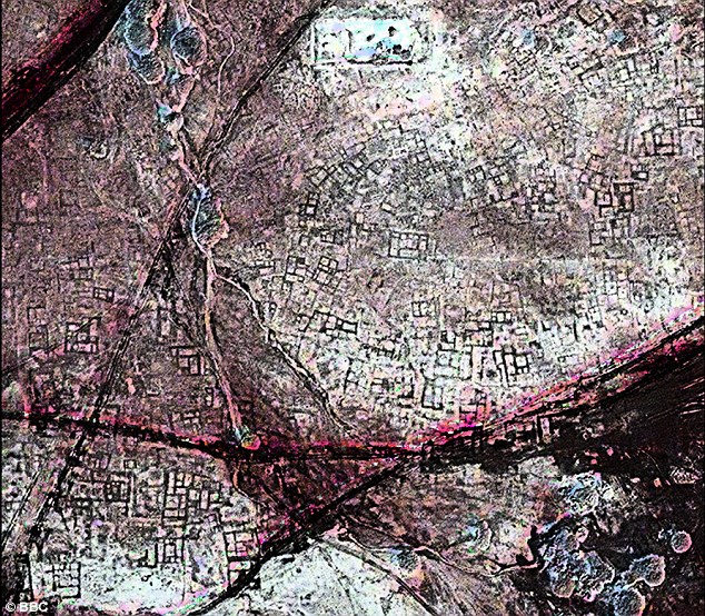
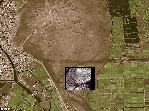
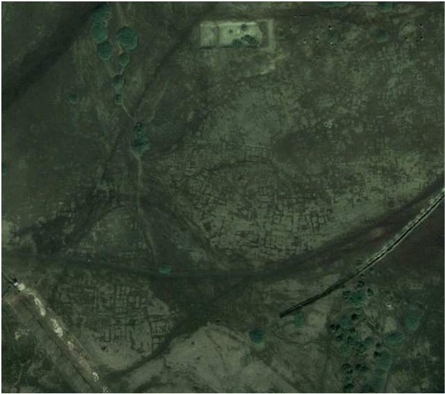
These thematic mappers take images in multiple wavelengths of electro-magnetic radiation (multi-spectral) and are usually found on Earth observation satellites, 7- prospect for minerals 8- کلید واژه: Satellite infra-red imaging 9- به این لینک دقیقا" توجه فرمایید: http://www.age-of-the-sage.org/space_archaeology/satellite_street_plan_tanis.html و این عکسها: http://www.age-of-the-sage.org/space_archaeology/tanis_street_plan_satellite_image.jpg http://www.age-of-the-sage.org/space_archaeology/tanis_map_location_1.jpg http://www.age-of-the-sage.org/space_archaeology/google_earth_tanis_street_map1.gif Satellite infra-red imaging Archaeologist Sarah Parcak says she has discovered thousands of ancient sites in Egypt, from pyramids to a detailed street plan of the city of Tanis, an A-to-Z of the region's northern capital – all thanks to images from satellites orbiting 700 kilometers, (or 435 miles), above the Earth. The infrared pictures are capable of tracing structures buried deep in the sand. "It just shows us," she adds, "how easy it is to underestimate both the size and scale of past human settlements." More than 1,000 tombs and 3,000 ancient settlements were also revealed by looking at infrared images which show up underground buildings due to the differing densities between the rather dense mud-bricks used in Ancient Egypt in building construction and the typically less dense surrounding sands or soils under which mud brick building foundations may often now lay buried. The cameras on the satellites are so powerful they can spot objects of less than a metre in diameter. The work has been pioneered at the University of Alabama at Birmingham by US Egyptologist Dr Sarah Parcak. She says she was amazed at how much she and her team has found. The full extent of the street plan of Tanis, once the capital of ancient Egypt, and a site made famous by the Indiana Jones film Raiders of the Lost Ark, has also been revealed ~ and appears to suggest a scale some four times greater than had previously been imagined. Thanks to satellite facilitated infrared imaging techniques Parcak discovered an ancient network of streets and houses at Tanis, which are completely invisible from the ground. An ancient streetmap: A satellite image shows a once densely occupied city of Tanis to be littered with underground tombs. Buildings in ancient Egypt were constructed out of mud brick – the material is dense, allowing satellites orbiting above Earth to photograph the outlines of structures completely invisible to the human eyes of even trained archaeologists in ground surveys. Modern city San El Hagar on the left, with the inset showing the location of ancient Tanis. Whilst researching this page we came across a Google Earth image of the same area. This image might be held to give some hint of what was there, in the way of an underlying Tanis street map, to be more fully dicovered by space satellite archaeology. On a larger scale map Tanis appears north-east of Cairo, and in the Nile Delta. To further test some of the most recent satellite finds, Parcak enlisted the help of a French archaeological team which already had a long history of digging at the 3000-year-old Tanis site. The satellite data revealed a warren of mud-brick walls, a maze-like street plan, and large residences that may have housed the wealthy. So the French team chose a structure from the images and excavated there. Beneath about 30 centimeters of sediments, they discovered mud brick walls. “They found an almost 100% correlation between what we see on the imagery and what we see on the ground,” Parcak says. “They’d excavated a 3,000-year-old house that the satellite imagery had shown and the outline of the structure matched the satellite imagery almost perfectly. That was real validation of the technology.” Dr Sarak Parcak is considerably enthuisiastic about implications of the satellite facilitated discernment of the street map of ancient Tanis. “This hints at the possibilities of discoveries to come,” she said. “I am excited for my generation and the generations to come. There is enough to be excavated for 50 generations to come.” Parcak’s research was funded by a grant from the BBC in hopes of exploring how satellite imagery can be used in conjunction with archaeology. Parcak worked with Zari Hawass, Ph.D., Egypt’s Minister of State for Antiquities, who was instrumental in her being allowed access to the excavation sites. This is the first time Parcak has done a discovery on this a large a scale, she said. She also plans to partner with Hawass for training young Egyptians to do this work as well. “It is important that we map out our ancient history before it’s gone,” she said 10- http://www.academia.edu/559396/Detection_of_ancient_Egyptian_archaeological_sites_using_satellite_remote_sensing_and_digital_image_processing 11- https://str.llnl.gov/str/April05/Vincent.html 12- http://www.dailymail.co.uk/sciencetech/article-1390667/Seventeen-lost-pyramids-thousands-buried-Egyptian-settlements-pinpointed-infrared-satellite-images.html |
| جمعه 4 مهر1393 - 10:22am |
|
|
|
صفحه 28 از 53 |
[ 529 پست ] | برو به صفحه قبلی 1 ... 25 , 26 , 27 , 28 , 29 , 30 , 31 ... 53 بعدی |
|
همه زمان ها بر اساس UTC + 3:30 ساعت تنظیم شده اند. |
چه کسی آنلاین است؟ |
کاربران حاضر در این انجمن: کاربر عضو شده ای موجود نیست. و 31 مهمان |
| در این انجمن نمی توانید موضوع جدید ارسال کنید در این انجمن نمی توانید به موضوعات پاسخ دهید در این انجمن نمی توانید پست خود را ویرایش کنید در این انجمن نمی توانید پست های خود را حذف کنید در این انجمن نمی توانید پیوست ارسال کنید |